Liste der Einträge im National Register of Historic Places im Greene County (Arkansas)
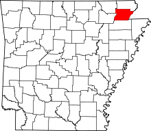
Die Liste der Einträge im National Register of Historic Places im Greene County in Arkansas führt die Bauwerke und historischen Stätten im Greene County auf, die in das National Register of Historic Places aufgenommen wurden.[1]
Legende
| NRHP | Historic Place |
|---|---|
| HD | Historic District |
Aktuelle Einträge
| [2] | Name[3] | Bild | Eintragsdatum | Lage | Ort | Beschreibung |
|---|---|---|---|---|---|---|
| 1 | Beisel-Mitchell House | 1996 ID-Nr. 96001031 | 420 West Court Street 36° 3′ 21″ N, 90° 29′ 27″ W36.055833-90.490833 | Paragould | ||
| 2 | Crowley's Ridge State Park-Bathhouse | 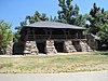 | 1992 ID-Nr. 92000537 | Crowley's Ridge State Park 36° 2′ 45″ N, 90° 39′ 50″ W36.045833-90.663889 | Walcott | |
| 3 | Crowley's Ridge State Park-Bridge | 1992 ID-Nr. 92000540 | Crowley's Ridge State Park 36° 2′ 42″ N, 90° 39′ 47″ W36.045-90.663056 | Walcott | ||
| 4 | Crowley's Ridge State Park-Comfort Station | 1992 ID-Nr. 92000538 | Crowley's Ridge State Park 36° 2′ 37″ N, 90° 39′ 37″ W36.043611-90.660278 | Walcott | ||
| 5 | Crowley's Ridge State Park-Dining Hall | 1992 ID-Nr. 92000536 | Crowley's Ridge State Park 36° 2′ 59″ N, 90° 39′ 48″ W36.049722-90.663333 | Walcott | ||
| 6 | George Ray's Dragstrip | 2006 ID-Nr. 06000075 | AR 135, rund 800 m südlich des US 412 36° 2′ 50″ N, 90° 26′ 4″ W36.047222-90.434444 | Paragould | ||
| 7 | Greene County Courthouse |  | 1976 ID-Nr. 76000412 | Court Square 36° 3′ 14″ N, 90° 29′ 12″ W36.053889-90.486667 | Paragould | |
| 8 | Gulf Oil Company Service Station | 1994 ID-Nr. 94000850 | Main Street Ecke South 3rd Street 36° 3′ 15″ N, 90° 29′ 17″ W36.054167-90.488056 | Paragould | ||
| 9 | Highfill-McClure House | 2002 ID-Nr. 02000260 | 701 West Highland Street 36° 3′ 28″ N, 90° 29′ 40″ W36.057778-90.494444 | Paragould | ||
| 10 | Jackson-Herget House | 1992 ID-Nr. 92000907 | 206 South 4th Street 36° 3′ 18″ N, 90° 29′ 26″ W36.055-90.490556 | Paragould | ||
| 11 | Linwood Mausoleum |  | 2007 ID-Nr. 06001314 | Kreuzung von West Kings Highway und Linwood Drive 36° 3′ 4″ N, 90° 30′ 11″ W36.051111-90.503056 | Paragould | |
| 12 | National Bank of Commerce Building |  | 1993 ID-Nr. 93000423 | 200 South Pruett Street 36° 3′ 19″ N, 90° 29′ 11″ W36.055278-90.486389 | Paragould | |
| 13 | Old Bethel Methodist Church | 1978 ID-Nr. 78000590 | Westlich von Paragould abseits des AR 141 36° 0′ 46″ N, 90° 39′ 30″ W36.012778-90.658333 | Paragould | ||
| 14 | Paragould Downtown Commercial Historic District |  | 2003 ID-Nr. 03000646 | Abgegrenzt durch 3rd Avenue, Kings Highway und West Highland Street 36° 3′ 19″ N, 90° 29′ 13″ W36.055278-90.486944 | Paragould | |
| 15 | Paragould War Memorial |  | 1997 ID-Nr. 97000554 | Kreuzung von 3rd Street und Court Street 36° 3′ 21″ N, 90° 29′ 20″ W36.055833-90.488889 | Paragould | |
| 16 | Texaco Station No. 1 | 2001 ID-Nr. 01000718 | 110 East Main Street 36° 3′ 16″ N, 90° 29′ 9″ W36.054444-90.485833 | Paragould |
Frühere Einträge
| [2] | Name[3] | Bild | Eintragsdatum | Lage | Ort | Beschreibung |
|---|---|---|---|---|---|---|
| 1 | Big Slough Ditch Bridge | 2004 ID-Nr. 00000629 | County Road 855 36° 4′ 10,3″ N, 90° 21′ 42,4″ W36.06952-90.36177 | Brighton | ||
| 2 | Eight Mile Creek Bridge | 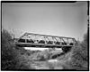 | 2004 ID-Nr. 90000524 | AR 135 36° 4′ 2,8″ N, 90° 29′ 25,9″ W36.0674519-90.4905139 | Paragould |
Siehe auch
Einzelnachweise
- ↑ Auszug aus dem National Register of Historic Places - Greene County Abgerufen am 1. Oktober 2012
- ↑ a b Die Nummerierung in dieser Listenspalte ist an der vom National Park Service vorgelegten Reihenfolge der Einträge orientiert; die Farben unterscheiden verschiedene Schutzgebietstypen des Nationalparksystems mit landesweiter Bedeutung (z. B. National Historic Landmarks) von den sonstigen Einträgen im National Register of Historic Places.
- ↑ a b National Register Information System. In: National Register of Historic Places. National Park Service, abgerufen am 24. April 2008 (englisch).
- Karte mit allen Koordinaten:
- OSM
- WikiMap

Einträge im National Register of Historic Places in Arkansas
National Register of Historic Places in Arkansas
Arkansas | Ashley | Baxter | Benton | Boone | Bradley | Calhoun | Carroll | Chicot | Clark | Clay | Cleburne | Cleveland | Columbia | Conway | Craighead | Crawford | Crittenden | Cross | Dallas | Desha | Drew | Faulkner | Franklin | Fulton | Garland | Grant | Greene | Hempstead | Hot Spring | Howard | Independence | Izard | Jackson | Jefferson | Johnson | Lafayette | Lawrence | Lee | Lincoln | Little River | Logan | Lonoke | Madison | Marion | Miller | Mississippi | Monroe | Montgomery | Nevada | Newton | Ouachita | Perry | Phillips | Pike | Poinsett | Polk | Pope | Prairie | Pulaski | Randolph | Saline | Scott | Searcy | Sebastian | Sevier | Sharp | St. Francis | Stone | Union | Van Buren | Washington | White | Woodruff | Yell


